
This post was co-authored by Dr. Marc Alessi.
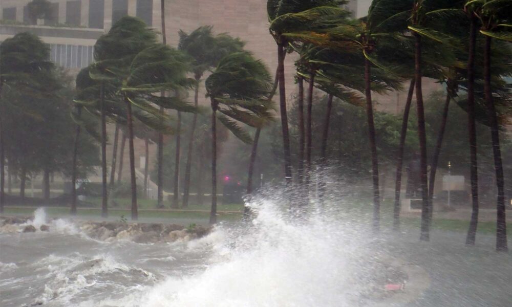
Here we are once again, on the cusp of the Atlantic hurricane season, which starts on June 1. That’s when we start regularly (maybe obsessively?) checking the National Hurricane Center (NHC) website for daily updates on the likelihood of tropical storm formation. This year, we’re bracing for what’s expected to be an active season made doubly dangerous by the Trump Administration’s cuts to agencies like the National Emergency Management Agency (FEMA) and the National Oceanic and Atmospheric Administration (NOAA)—the parent agency of the National Weather Service (NWS) and the NHC.
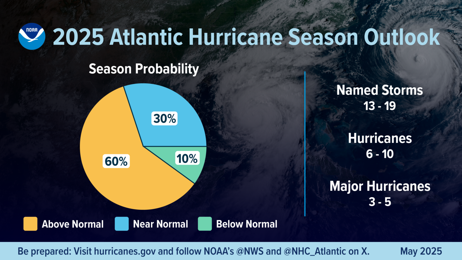
On May 22, NOAA released its outlook, forecasting with 70% confidence an above-average hurricane season, with 13 to 19 named storms—6 to 10 of which could become hurricanes, with 3 to 5 of those being major (Category 3-5).
That was in line with Colorado State University’s 2025 hurricane season forecast, which called for another above-average season with 17 named storms, of which 7 are likely to become hurricanes—4 of them major. Usually the first forecast out, Colorado State also releases multiple updates throughout the season as well as a wrap-up analysis.
These forecasts may look less daunting than the ones for 2024, which was predicted to be a significantly above-average hurricane season, more active than 2025. Those forecasts were right: 2024 ended up as one of the costliest hurricane seasons on record, with Hurricanes Milton (a category 3 at landfall) and Helene (a category 4 at landfall) causing the most damage in the continental US. Hurricane Helene was also one of the deadliest hurricanes since 1950. While 2024 hopefully shouldn’t be as severe as the 2025 hurricane season, the fact remains that an above-average season is expected, and it only takes one severe landfalling hurricane for the costs and harms to people to be significant.
Why an above-average season?
There are several factors that guide hurricane forecasters when they make their seasonal outlooks, two of which are mainly responsible for this year’s expected above-average hurricane season:
- Sea surface temperature (SST): this is really what the name says—the temperature of the water on the ocean surface. Currently, SSTs are above normal across the Caribbean Sea, Gulf of Mexico, and most of the Atlantic Ocean where hurricanes typically form. And there’s a clear climate change signal: according to Climate Central’s Climate Shift Index, these warm ocean temperatures are 30x more likely due to fossil fuel-caused climate change. Why does the temperature of the ocean surface matter for hurricanes? For hurricanes to form, SSTs must be at least 30 degrees C (86 degrees F). These warm waters act as fuel for hurricanes. If a tropical storm develops over warmer-than-usual waters, the tropical storm has more fuel to work with to strengthen into a hurricane. Therefore, warmer waters are a strong predictor of how many hurricanes we might see during hurricane season, which is why both forecasts stress this variable as one of their main reasons for an above-average season.
- The El Niño-Southern Oscillation (ENSO): Currently, we’re in a neutral phase of ENSO, meaning neither El Niño nor La Niña is occurring, and according to the May forecast from the Climate Prediction Center, this neutral phase is likely to continue through the hurricane season. This is another reason for an above-average season. ENSO is a natural 5-to-7-year oscillation, or cycle, of ocean temperature in the eastern Pacific Ocean. During a La Niña, the ocean temperatures are cooler in this region, and during an El Niño, they are warmer. The latter is linked to increased vertical wind shear (the change in wind speed with height) over the Atlantic Ocean and Caribbean Sea, which breaks down tropical cyclone formation, leading to fewer hurricanes developing. La Niña does not have this characteristic, and because of this, La Niña years usually tend to have more hurricanes. So what’s happening this hurricane season? An El Niño, which would be a better scenario for fewer hurricane formations, is unlikely to develop; hence the above-average season.
What else will we be following this season?
Last year was a hurricane season for the record books. Hurricane Beryl was the earliest Category 5 hurricane in Atlantic recorded history, and Hurricanes Milton and Helene both underwent periods of rapid intensification, defined as a strengthening of winds of at least 35 mph in a 24-hour period, thanks in large part to SSTs being 2°C warmer than usual. These rapid intensification rates experienced by Helene and Milton are part of a larger trend in the Atlantic Ocean: hurricanes have increasingly undergone periods of rapid intensification since 1982 as a result of warmer waters due to fossil-fuel caused climate change. When these warmer waters are near the shore, hurricanes can intensify quickly just before landfall, creating an added layer of danger and preparedness needs.
Luckily, there is a silver lining to this. In 2024, the NHC had an incredibly accurate year forecasting the worst the season had to offer. The NHC predicted that both Milton and Helene would undergo periods of rapid intensification well in advance, which provided ample warning time to residents in Florida where the storms eventually made landfall. In fact, Helene was predicted to undergo rapid intensification when it was just a tropical disturbance, not even a fully formed tropical storm!
And the forecast for Milton was even more impressive: the very first advisory issued by the NHC for Milton predicted it would make landfall in Florida only 12 miles away from its actual landing spot! That was an incredibly accurate forecast made days in advance. But our ability to forecast storms this accurately is threatened by the Trump administration actions to slash federal agencies.
Above-average concerns added to an above-average season
This year, we enter hurricane season with heightened risks because of the Trump administration’s actions against NOAA and FEMA that have already undermined preparedness and could severely harm disaster response. And this certainly raises concerns.
Forecasts and warnings are an essential part of hurricane awareness. The NHC has historically monitored the Atlantic in a variety of ways in order to identify possible tropical storm formation, evolution, and ultimately hurricane development and trajectory.
In addition, resources such as hurricane hunter airplanes are key to identifying what is going on inside a hurricane, getting information on speed, strength, and other data, which then allows the NHC to issue a better forecast. The NHC also has an incredible lineup of weather and hurricane models and resources that have been perfected over the years by NOAA research laboratories, the same ones that are facing cuts from the Trump administration. If cuts to NOAA (and the NHC) continue, they are likely to diminish forecast accuracy and confidence, and communities at risk of an approaching hurricane may lack the resources to properly prepare and respond.
We also know that preparedness is key during hurricane season. That includes planned emergency responses such as evacuation plans, shelter, supplies, rescue and recovery. In the past, communities could count on the federal government and FEMA to come through after a hurricane (or any other disaster) hit.
Our colleague Shana Udvardy has been tracking the Trump administration’s attacks on FEMA and the potential consequences to people of its downsizing through cuts to the agency’s staff, programs and mission. According to her, the proposed shift of the burden of disaster response from the federal government to state and local government will create significant risk and harm for communities in the path of and reeling from disasters. Instead of making cuts, she says, the administration should strengthen FEMA.
Trump administration’s actions raise risks of bad outcomes
Cuts to NOAA and FEMA hinder our country’s ability to properly and safely respond to hurricane threats and other disasters. With climate change leading to stronger and more destructive hurricanes with intensifying wind and rainfall, and a higher likelihood of hurricanes making landfall along certain areas of the US coast, we can only hope that, if a hurricane makes landfall, communities on the storm path will be prepared and receive the assistance they need to get back on their feet.
Congress must work to counteract the Trump administration actions, ensuring NOAA and the NHC are fully funded and staffed so that hurricane experts at the NHC continue issuing lifesaving forecasts. Congress must also ensure a fully funded and staffed FEMA is ready to respond to any hurricane landfall this season.