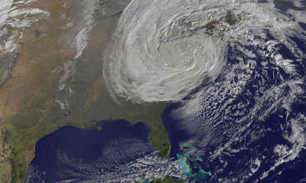

This weekend, forecasters at NOAA’s National Weather Service are following the potential development of a powerful low-pressure system that could bring major flooding and winds to coastal Southern and Mid-Atlantic states. This comes just a week after high surf from Hurricanes Humberto and Imelda led to the collapse of eight houses on North Carolina’s Outer Banks. According to the Washington Post, the developing low-pressure system could meet “subtropical” criteria, perhaps earning the name “Karen” from the National Hurricane Center.
While we will be following this storm closely, especially given the potential limited response of the government during the shutdown, it’s important to know the differences between the types of storms that impact the US. Why are they named nor’easters or hurricanes? What makes a storm “subtropical?” How do they form? And finally, how are they changing due to fossil fuel-caused climate change?
Two main types of storm systems: extra-tropical and tropical
A storm system, also called a low-pressure system or a cyclone, is usually either extra-tropical or tropical in nature. While both extra-tropical and tropical cyclones bring weather to people living in the US, they are vastly different in their energy source, their structure, their size, their movement, and their seasonality. But they both have a similar goal: establishing equilibrium in the Earth’s climate system.
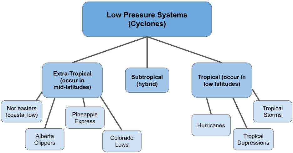
Diagram showing the different types of low-pressure systems (or cyclones). Union of Concerned Scientists.
What do I mean by this? In a previous blog on the Atlantic Meridional Overturning Circulation (AMOC), I mentioned how the Earth’s climate system’s main goal is to establish temperature equilibrium by mixing warm water or air near the equator with areas of cool water or air near the poles. The AMOC is an example of this: it brings warm water from the Equator to the North Pole and mixes it with cooler water and vice versa, moving our planet closer to temperature equilibrium.
Extra-tropical and tropical storm systems are just another tool in Earth’s toolbox to establish equilibrium. They both mix areas of warmer and cooler masses in order to establish temperature equilibrium.
Tropical cyclones
Tropical cyclones form in the Tropics (between 30S and 30N) due to significant temperature differences between the ocean and the upper atmosphere. When ocean waters are warm (greater than 26°F or 79°F), they start to evaporate into the atmosphere to form clouds and rain, which redistributes heat from the ocean to the atmosphere. This results in a “mixing” between the very warm ocean and the cooler atmosphere in an attempt to establish temperature equilibrium.
As that storm system gains more energy from the ocean, it begins to rotate due to the rotation of Earth, forming a tropical depression, the earliest stage of a tropical cyclone. If conditions remain favorable, the cyclone will then strengthen into a tropical storm and eventually, if in the Atlantic or Eastern Pacific Ocean, a hurricane. Once a cyclone reaches “tropical storm” status, it is given a name by the National Hurricane Center.
Given that tropical cyclones get their energy from warm sea surface temperatures, you might guess that fossil fuel-driven climate change, which is rapidly warming the Earth’s oceans, affects tropical cyclone development. When ocean temperatures are warmer, hurricanes have more energy to feed off, allowing them to strengthen more rapidly and into a more intense hurricane. We know that more hurricanes in the Atlantic are rapidly intensifying due to warmer ocean temperatures. And according to an analysis by Climate Central, all hurricanes during the 2024 hurricane season were made stronger due to these warmer ocean temperatures.
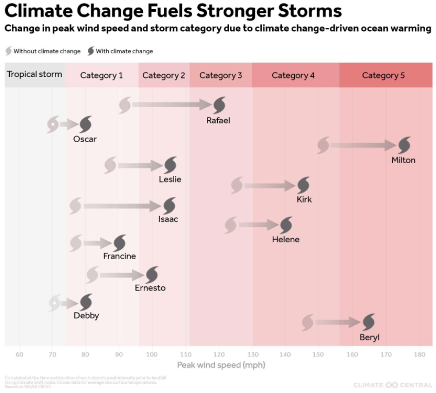
Climate change and warmer ocean temperatures are making hurricanes (or tropical cyclones) more intense than in a world without climate change. Source: Climate Central.
Extra-tropical cyclones
Extra-tropical cyclones form outside of the Tropics and get all of their energy from a horizontal temperature contrast between warm and cold air masses. The US sits in a perfect position to experience extra-tropical cyclones: to the north of us is cold, Arctic air, and to the south of us is hot, tropical air. Again, the climate system is always trying to mix warm and cold air masses to establish temperature equilibrium. Extra-tropical cyclones develop in order to mix these two air masses.
There are four typical extra-tropical storm systems that affect weather here in the US: the Alberta clipper, the Colorado low, the Pineapple Express, and the Nor’easter (or a coastal low). Extra-tropical cyclones travel from the west to east, following something called the jet stream, which is a river of fast-moving air in the upper atmosphere that serves as a “highway” for these storm systems. Extra-tropical cyclones are also unique in that they have warm fronts and cold fronts, or leading edges of different air masses that push into regions as the cyclone moves across the US.
Each of these extra-tropical storm systems can be weak or strong, big or small. A powerful pineapple express, which is really an atmospheric river steering low pressure systems into the western states, can bring intense precipitation during the winter months. A powerful Colorado low can produce supercell thunderstorms in the spring that lead to the formation of tornadoes. And a nor’easter riding up the East Coast can bring feet of snow to inland and coastal communities in the winter, along with high surf and wind.
Extra-tropical cyclones in general are feeling the effects of climate change. As the atmosphere warms, it will be able to hold more water (check out the sponge analogy in this blog), allowing for more intense precipitation to be carried by any of these extra-tropical storms. We are especially seeing this in the atmospheric river of the pineapple express. And earlier this year, a study was released showing that nor’easters are strengthening in part due to a greater contrast between cold air moving south from the North Pole and a significantly warmer ocean.
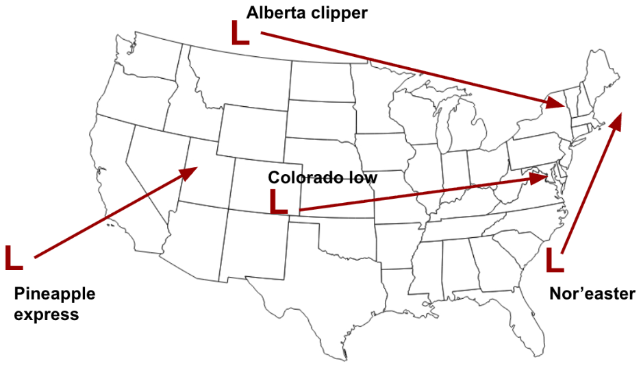
The four typical extra-tropical storm systems that affect the US. Union of Concerned Scientists.
A nor’easter that’s subtropical?
This weekend, we’re following a developing nor’easter, or a coastal cyclone, that will bring high surf and wind to coastal states in the South up through the Northeast. By now, you know that a nor’easter is an extra-tropical cyclone. But wait! The nor’easter may become “subtropical”!?
A subtropical cyclone is quite fascinating: it is sort of a hybrid between an extra-tropical and tropical cyclone. Why? A subtropical cyclone gets its energy from the warm ocean waters (like a tropical cyclone) AND a horizontal temperature contrast (like an extra-tropical cyclone)! Oftentimes, subtropical cyclones will still be given names from the National Hurricane Center if they have the equivalent strength of at least a tropical storm.
In fact, when Hurricane Sandy made landfall in New Jersey in October of 2011, it was a subtropical storm. It was getting its energy from not just warm ocean waters, but also from a sharp contrast in temperature between Canada (very cold air) and the Southern US (very warm air). It was trying to mix these two different air masses, along with the warm ocean waters and cold upper atmosphere.
Why are nor’easters called nor’easters?
To end on something fun, you might be wondering, why are nor’easters (short for northeasters) called nor’easters? It all has to do with the wind direction. Meteorologists describe wind in what direction the wind is coming from (rather than where it’s heading to). For example, if there was a northerly wind, that means the wind is coming from the north and heading to the south. As a nor’easter moves up the coast, it brings powerful northeast winds into New England. These extra-tropical cyclones have been referred to as nor’easters since at least the early 19th century in New England. Since then, we’ve seen several legendary nor’easters: the Portland Gale Nor’easter of 1898 was so powerful that it changed the shape of the Massachusetts coastline, and the 1993 Storm of the Century Nor’easter dumped over 40 inches of snow in Upstate New York!