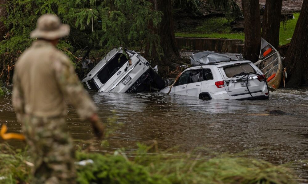

Since the start of July, multiple deadly flash flood events have occurred in the US, including those in Central Texas that killed over 130 people (27 of them children and counselors at Camp Mystic), the New York City metropolitan area where two people drowned in a submerged car, and in New Mexico and the DC area.
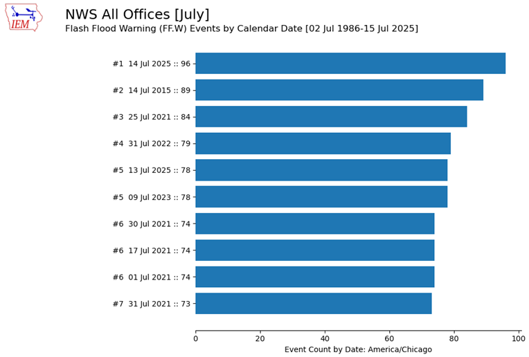
This intensity of flooding events is, unfortunately, our new normal. As of July 15, the National Weather Service (NWS) issued more flash flood warnings in 2025 than any year on record dating back to 1986. On July 14, the NWS issued more flash flood warnings for one July day than ever before.
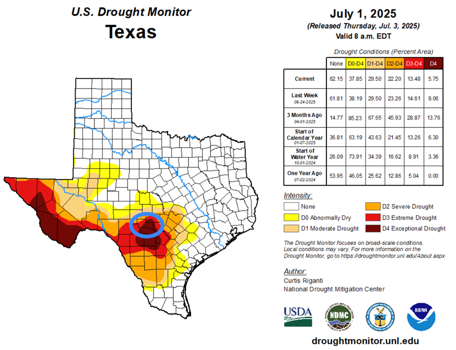
While parts of the country have been inundated with flash floods, the Western and Southern US, including Oregon, Arizona, New Mexico, and Texas, are simultaneously facing extreme to exceptional drought. Strikingly, some of the same regions hit by recent flash flooding were previously experiencing drought conditions.
So what gives? How are we experiencing more extreme rainfall events and droughts at the same time? And why are they so intense? Well, the short version is that we are in a warmer world primarily from the burning of fossil fuels. The warmer that world becomes, the more extreme both flash floods and droughts become. In this post, I’ll walk through the changing atmospheric mechanism that is producing these more intense floods and droughts, and also talk about something called “hydroclimate whiplash.”
The atmosphere is a gigantic sponge
The same physical mechanism helps explain both the increasing intensity of extreme rainfall events and worsening droughts. You read that right: something in the atmosphere is changing that is leading to both more intense floods and more intense droughts simultaneously.
This mechanism can be described by a thermodynamic principle known as the Clausius-Clapeyron (CC) Relationship, which basically says that as atmospheric temperature increases, the amount of water vapor the atmosphere can hold also increases. You’ve probably noted this in your daily life: in the wintertime, when it’s cooler, it rains or snows much less than in the summer. This is because the atmosphere holds much more water during the summer, thanks to the warmer overall temperatures. To put numbers to it, for every 1 degree Fahrenheit increase in temperature, the atmosphere holds 4% more water.
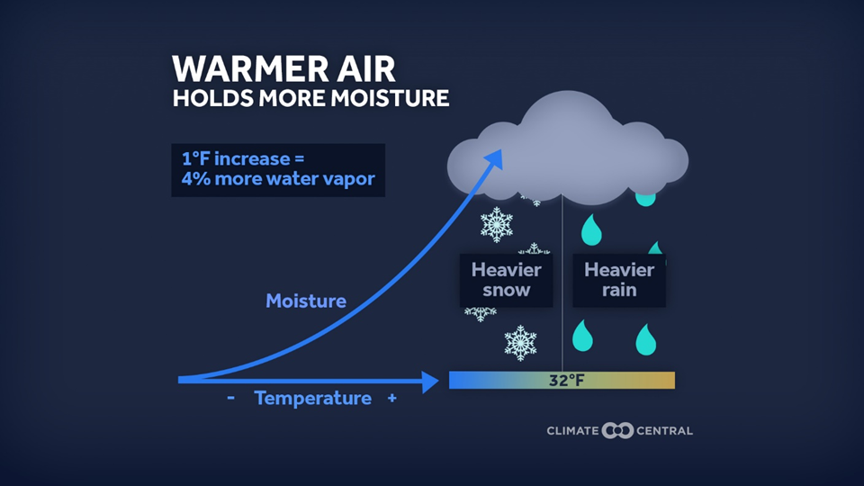
Here’s a helpful analogy: imagine the atmosphere as a sponge. It will absorb water until it reaches its limit. When the sponge is wrung out, the water it was holding will fall to Earth’s surface. As the atmosphere warms, this sponge gets bigger, meaning that it can both hold more water and release more water when the sponge is wrung out.
With fossil fuel-driven climate change, the atmosphere is warmer, so our atmospheric “sponge” is much bigger. Since it’s bigger, it can hold more water without reaching its maximum holding capacity, allowing for longer periods of time with no rainfall. This results in more droughts. But when it finally does release that moisture, it unleashes much more water at once, resulting in more intense flash flooding.
Heavier downpours are part of a long-term trend
The deadly flash floods observed over the last month are part of a larger trend that reflects our changing atmosphere. From 1958-2016, every region in the contiguous US observed an increase in the heaviest precipitation events. In other words, when it downpours, it’s downpouring more than it used to, thanks in part to our larger atmospheric sponge.
This signal is especially significant in the Northeast and the Midwest, where downpour intensity increased 55% and 42%, respectively, between 1958 and 2016. While there may not be a clear signal in the number of flash flooding events—for example, this paper from 2019 found no statistical change in the frequency of flash flood alerts—the flash floods that do occur are becoming more intense.
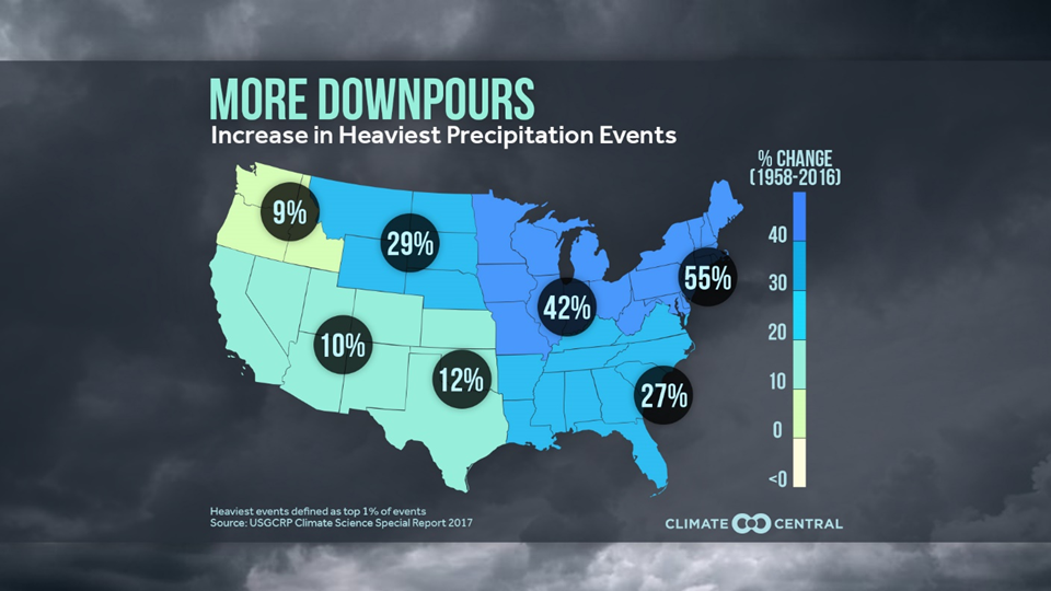
Whether you observe more downpours where you live depends on other factors, and not just the CC Relationship. For example, in the figure above, we see that the Northeastern US (NE) is seeing more downpours compared to the Northwestern US (NW), despite the atmospheric sponge being the same. Why? There are many factors involved in how changes in extreme events manifest locally, but here are two higher-level reasons why this may be.
First, the NW and NE observe different types of storms during the summer months when downpours typically occur. Storms in the NE tap into the nearly infinite amount of moisture in the Atlantic and Gulf of Mexico. The atmospheric sponge carries that water over to the NE and is wrung out all over the region. In contrast, the Pacific Ocean off the NW coast is much cooler and provides less energy for evaporation, meaning less moisture enters the atmosphere to fuel storms there.
Second, while the CC Relationship provides a general guideline, some extreme rainfall events are intensifying even faster than it predicts. For example, in this study from 2017, scientists found that extreme rainfall events over the Netherlands were actually increasing twice as fast as the CC relationship! This faster increase, known as super-CC scaling, is likely due to a combination of factors, including more moisture near the surface, stronger storm updrafts, and larger areas of rising air that bring in additional water vapor. In short, it’s not just that the atmospheric “sponge” is getting bigger, it’s also squeezing out more water, more quickly, during certain types of storms.
Why a warmer world means more drought
As the world warms, evaporation increases. Think of a summer day when it rains and then the sun comes out. A puddle that forms from the rain immediately evaporates if it’s warm and dry enough. Now apply this on a global scale in the face of global warming: the ground everywhere is drying out faster given the warmer atmosphere and more heatwaves, which leads to more drought. At the same time, our atmospheric sponge can also hold more water without it raining. So even if more water is in the atmosphere from faster evaporation rates from the Earth’s surface, it won’t rain because the atmosphere will hold it longer.
Both long-term droughts, which lasts longer than six months, like the one in the Southwestern US that may last until the end of the century, and short-term droughts, which normally last a season or two, are becoming more common and intense. In my master’s program, we analyzed how flash droughts may become more common in the Northeastern US due to soils rapidly drying after the winter season due to warmer temperatures. And overall, short-term droughts have increased in 74% of the land regions on Earth.
Hydroclimate whiplash
On July 4, over 130 people tragically lost their lives due to a 1-in-1000 year flash flooding event. In other words, there is only a 0.1% chance of this event happening in any given year. Our team blogged about what to know about this flash flooding event, including the response of the NWS, which is still dealing with cuts from the Trump administration’s layoffs and early retirements.
In that post, we mentioned that the flash floods were likely related to climate change due to the overall increase in downpours from the same atmospheric sponge mechanism. We also noted that right before the flash flood event, Kerrville, the epicenter of the worst flooding along the Guadeloupe River, was in exceptional drought conditions, the worst type of drought issued by the US Drought Monitor. Because of the drought, the soils couldn’t absorb any of the 10+ inches of rain that was dumped on Kerr County, leading to significant runoff and river water rise.
This drought-to-flash flood is an example of a “hydroclimate whiplash” event, a sudden transition between a very dry period and a very wet period. These whiplash events are becoming more common with global warming as the atmospheric sponge holds more water, resulting in longer dry conditions followed by an intense release of water when the sponge is wrung out. Our team has talked about these whiplash events and their impacts for years.
Our changing climate
We are now dealing with the repercussions of the unchecked burning of fossil fuels. This uptick in extreme weather was predicted to happen for decades, and yet we’ve seen many of the world’s fossil fuel companies further pollute and warm our atmosphere while spreading disinformation about the science behind climate change.
This past month has been a devastating reminder of our changing climate. The deadly floods in Texas, New Jersey, and New Mexico, in addition to the flash flooding in Appalachia last year following Hurricane Helene, all reflect the increasing intensity of downpours across the US. Given the number of lives lost in these storms, it is clear the US is not prepared to deal with these extreme rainfall events in locations that aren’t used to this level of flooding. After all, the Central Texas floods occurred in “flash flood alley”—but we are entering an era with a new baseline for flash flooding that can catch seasoned folks off-guard.
We need to be sure the government continues to fully fund NOAA, including its Office of Oceanic and Atmospheric Research, so that we can continue to understand how these storms will evolve in the future. We need to continue to invest in precipitation modeling programs like Atlas 15 that had been on pause by the Trump administration and suddenly restarted after the Central Texas floods. Congress must also ensure robust investment in FEMA—especially its supplemental funding for FEMA’s Disaster Relief Fund, which is expected to run dry in September—in order to properly prepare for and respond to these events. We can’t let the Trump administration continue its attacks on FEMA; already, it has been dropping the ball on the Central Texas floods.