

You’ve probably seen in the news the potential for a super El Niño to develop this summer into early fall. According to NOAA’s Climate Prediction Center, there is at least a 50% chance of a “strong” or “very strong” El Niño during the upcoming Northern Hemisphere Winter. Some climate models, such as those at the National Center for Atmospheric Research (NCAR), are even saying this event could be the strongest El Niño on record.
But what exactly is El Niño, and what makes this event super? And what happens when El Niño interacts with fossil fuel-caused climate change—the long-term increase in global temperatures that is already turbocharging extreme weather events around the world? Unfortunately, the two of them together might be bad news for our climate system.
El Niño events are a natural part of Earth’s climate system
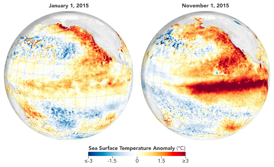
El Niño events are characterized by warmer-than-usual ocean surface temperatures in the eastern Equatorial Pacific off the coasts of Ecuador and the Galapagos Islands. Despite the ocean surface warming being rather small in area compared with the rest of the world’s massive oceans, the impacts of El Niño events are far-reaching. They affect weather patterns around the world, even at home here in the United States.
Super El Niño events are more intense than regular El Niño events. In a super El Niño, the eastern Equatorial Pacific experiences an extreme amount of warming, bringing about an even more forceful change to weather patterns around the world.
El Niño events, and even super El Niño events (though more rarely), have likely been happening for at least the last 10,000 years. Because of their far-reaching impacts on the world’s weather patterns, El Niño may have led to the demise of several ancient civilizations including the Moche and the Inca.
El Niño is part of the El Niño Southern Oscillation (ENSO). This oscillation is defined by three states: an ENSO neutral phase, a La Niña phase, and an El Niño phase. During ENSO neutral conditions, easterly winds flow across the tropical Pacific, pushing warm water toward Indonesia. Sometimes, these winds strengthen, pushing more warm water into Indonesia, cooling the Central and Eastern Pacific, and causing a La Niña to develop. An El Niño is characterized by weaker easterly winds in the Pacific, pushing less warm water to Indonesia and warming the Central Eastern Pacific more than usual. For more information, check out this excellent climate.gov blog on ENSO, where you’ll learn about how the ocean and atmosphere work together to bring about the different states of ENSO.
El Niño and climate change together is bad news for us
2024 was the hottest year in recorded history, and the past three years (2023-2025) averaged more than 1.5°C above preindustrial levels. This is all due to fossil fuel-caused climate change. Earth also typically experiences a warmer year than usual when an El Niño event is present (check out the section “El Niño impacts on the rest of the world” below). Combine this with global warming, and you get a very warm year, often record-breaking. If a super El Niño event develops later this year, it could push Earth to new global temperature records.
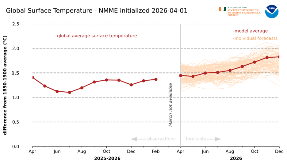
Check out this figure above: the orange lines on the right represent different model forecasts for global surface temperature anomaly later this year. Some climate models show global temperatures briefly exceeding 2.0°C above preindustrial levels, driven by the potential super El Niño later this year combined with global warming. This would be the first time in recorded history the planet reaches a temperature anomaly this warm, and not to mention we just passed the 1.5°C warming threshold for the first time in 2024!
While the majority of models predict global monthly temperature anomalies will remain below 2.0°C, the fact that there’s a nonzero chance of +2.0°C happening is shocking, and would signify a major acceleration in fossil fuel-caused climate change, pushing us closer to crossing some tipping point thresholds. Needless to say, we don’t need climate change and El Niño mixing. And since El Niño is a natural part of the climate system we can’t control, maybe we should back off on emitting fossil fuels and causing global warming!
El Niño impacts in the United States
El Niño events affect weather patterns around the world, including here in the United States. The figure below highlights these changes during an El Niño: the northern part of the country usually experiences warmer weather than normal, and the southern part of the country is usually wetter and cooler than normal.
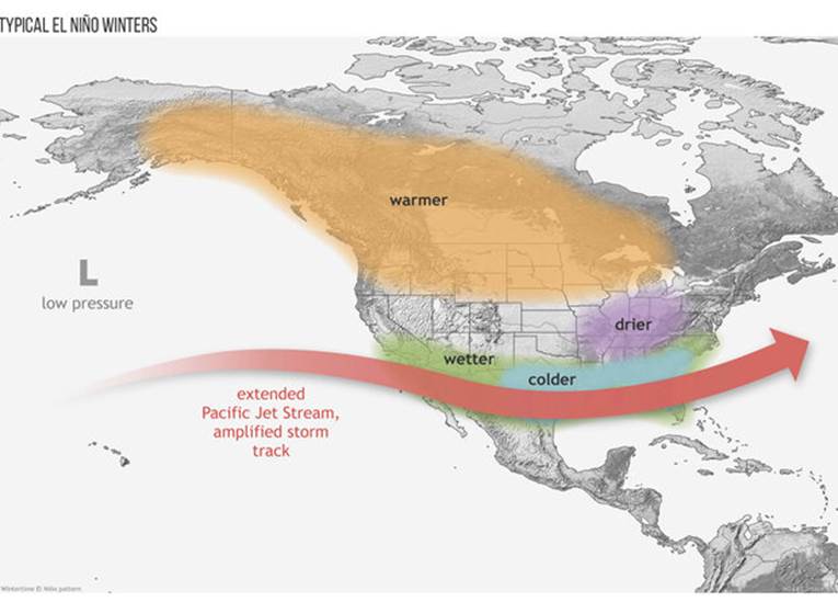
The thing is, it’s not a guarantee these regions will experience these conditions during an El Niño. For example, while coastal California typically sees more rain in the winter than usual during an El Niño, it actually saw less rain than normal during the 2015/2016 super El Niño, which was one of the strongest El Niño events on record. However, California’s two wettest years on record since 1951 were both El Niño years (1982-1983 and 1997-1998), and El Niño years on average do result in more rain than La Niña and ENSO neutral years in California.
Of course, some extra rain for the Southwest would be helpful next fall and winter. The west, especially its interior portions, is undergoing a short-term drought due to a dry winter season this past year, and a longer-term megadrought that started 26 years ago. Additionally, the west experienced record-shattering temperatures last month that were virtually impossible without climate change. Some cities broke their all-time maximum April high temperature records in March! The heatwave worsened an already-terrible drought, with record-low snowpack across much of the west developing, which could lead to an active upcoming wildfire season.
Could the El Niño bring some much-needed rain to the West? Could it bring too much rain like the intense flash floods of the 1997-1998 El Niño? It’s still too early to say. It’s worth noting that El Niño’s impacts in the US are typically restricted to only late fall and winter months. So any extra rainfall influenced by El Niño won’t arrive until then at the earliest.
El Niño impacts on the rest of the world
El Niño events affect weather patterns around the world as well. If there’s an El Niño present during the summer and fall season, which is likely for this year, it can actually suppress hurricane activity in the Atlantic Ocean and Caribbean Sea. This is because El Niño causes an increase in the amount of descending air over the Caribbean.
In order for a hurricane to develop, it needs rising, moist air. Without rising air, you don’t get hurricanes. This fact is reflected in the latest hurricane season forecast from Colorado State University, which is predicting a slightly below-average season due to the likely development of El Niño this summer.
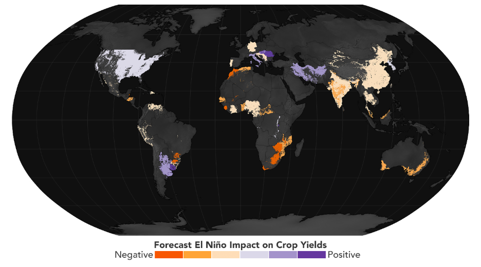
Impacts don’t stop in the Caribbean though: El Niño typically suppresses the Indian monsoon, while southern African nations, Indonesia, and Australia typically experience drier and hotter conditions than usual. Because of this, El Niño events impact crop yields around the world (check out the figure below from NASA).
Lastly, it’s important to note that during strong El Niño events, Earth typically records a new maximum global temperature record, as I mentioned earlier. This is because of two things: one, the planet is warmer overall during an El Niño event, and two, fossil fuel-caused climate change is gradually warming the planet. The warmest years up to a certain point are caused by the combination of El Niño, a natural part of Earth’s climate system, and climate change, which is human caused!
Take a look at the figure below. You can think of El Niño as kind of an escalator, slowly pushing global mean temperatures to new records thanks to climate change.
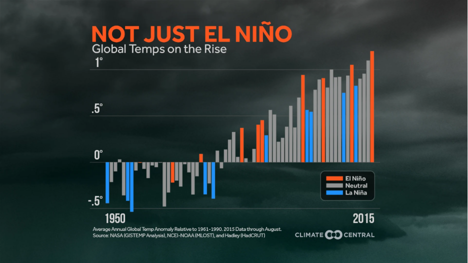
It’s worth noting that 2024, the hottest year on record, actually occurred during an ENSO neutral year, and 2023, which was the third hottest year on record (or tied for second, depending on the source), occurred during a La Niña. But scientists are also still debating why 2023 and 2024 were so hot. All this to say it’s not a guarantee that an El Niño event will push the planet to record warm temperatures.
Climate Change and El Niño in more detail
El Niño is a part of ENSO, which is a natural oscillation in Earth’s climate system. But we live in a changed world due to the burning of fossil fuels. The world is warming at an accelerating pace, and because of that warming, the planet’s ocean and atmosphere system is fundamentally different.
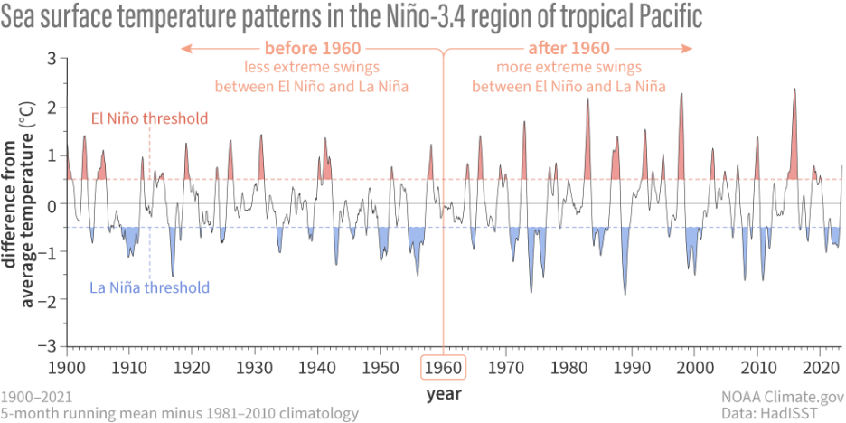
While the Intergovernmental Panel on Climate Change’s (IPCC) Sixth assessment report found no clear evidence of an impact of climate change on ENSO (summarized nicely by a climate.gov blog here), a study published in 2023 found that variability in ENSO was changing due to climate change. Check out the figure below by climate.gov: before 1960, El Niño and La Niña events existed, but they weren’t that intense.
After 1960, it’s clear we began to see more intense swings between La Niña and El Niño. In the 2023 study by Cai and colleagues, they found that this change in ENSO amplitude is actually a signal of fossil fuel-caused climate change, and this behavior shows up in historical climate model simulations with added heat-trapping gases, like carbon dioxide, in the atmosphere.
El Niño’s relationship with climate change doesn’t stop there. In a study published in 2024, scientists found that the impacts of ENSO on weather patterns around the world (called “teleconnections”) will worsen. Regions whose weather patterns change as a result of ENSO can expect those changes to become more extreme under climate change. And in a groundbreaking paper released just last month in Nature, scientists found that ENSO will also drive more extreme changes in regional ocean surface temperatures as a result of these strengthening teleconnections.
Again, if a super El Niño event develops later this year, Earth could be in for record-breaking global temperatures. Stay tuned as we continue following the developing El Niño this summer.