
We’re in the midst of a record-breaking super El Niño event in the Pacific Ocean, and the Southwestern US is already experiencing the significant impacts of a record Pacific hurricane season: flooding rains, and sharply elevated sea levels. Beaches are eroding, infrastructure is cracking, homes are slumping into the sea—and things are about to get significantly worse. What is happening here and why?
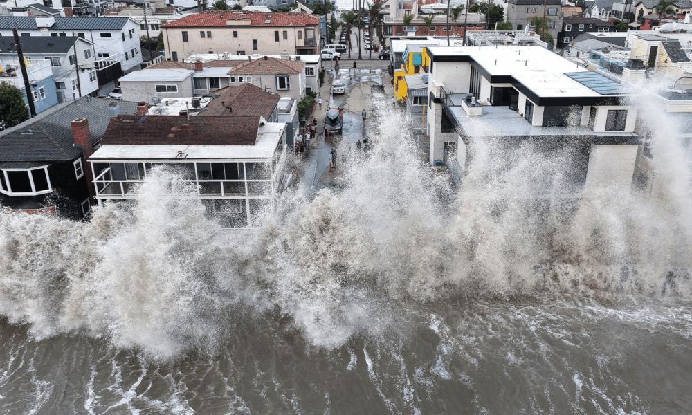
In early October, Long Beach residents were evacuated from their homes, which were battered by waves from Tropical Storm Rachel. Many oceanfront houses were damaged by the relentless impacts from waves. But it wasn’t just Tropical Storm Rachel pushing the ocean into homes, it was a combination of many factors, including sea level rise from fossil fuel-driven climate change, the intense marine heatwave off the California coast, and a Kelvin wave from the super El Niño.
These ingredients combined to produce water levels over several days that were 1.6 feet higher than the predicted tide, approaching record tide levels for Los Angeles County. Rachel’s waves were occurring on top of this increase in the normal tide, a combination that destroyed homes along the county’s coastline.
But how exactly do all of these factors combine to raise sea levels? Here’s a primer on Kelvin waves, marine heatwaves, sea level rise from climate change, and more, to get a full understanding of what the coastal communities in California now face and will have to deal with on a worsening basis during the upcoming super El Niño-charged winter.
King Tides and overlapping peaks in multi-year tidal cycles
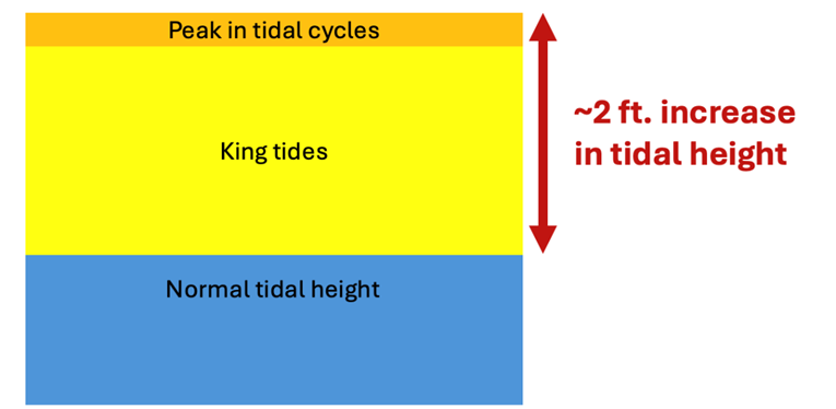
This fall and winter will feature the naturally occurring king tides, which occur when the Earth, moon, and sun come into alignment, resulting in the year’s highest water levels. Just the king tides alone add about 1-2 feet to average high tides.
But this is also a very important year: tidal cycles that peak every 4.4 years and every 18.6 years are both, unfortunately, expected to peak this year, bringing even higher king tides than usual. According to Patrick Barnard at UC Santa Cruz, this would result in an extra 2-4 inches of sea level rise this winter, on top of the already 1-2 feet increase from king Tides, with repeated peaks around Thanksgiving, Christmas, and MLK Day, around the successive full moons.
Sea level rise from fossil fuel-driven climate change
Yes, the planet is warming. Yes, it’s because of emitting heat trapping gases, like CO2, into the atmosphere. The oceans have absorbed an astonishing 91% of the added heat to the climate system due to fossil fuel-driven climate change. Over the past century, the oceans have warmed drastically, and this has had major implications for sea level rise.
The first mechanism raising global sea levels is something called thermal expansion. When water is warmer, it takes up more space, leading to higher sea levels around the world. The second is the melting of glaciers and ice sheets, which recently became the dominant source of sea level rise.
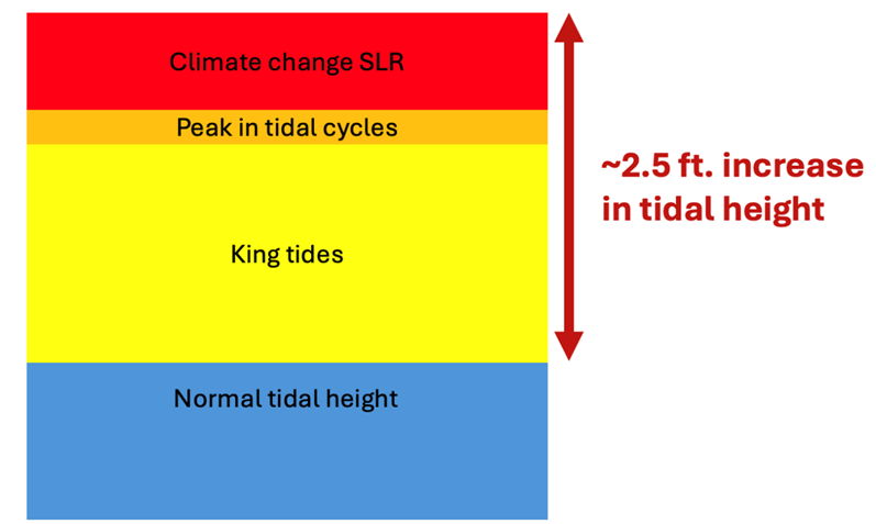
Put the melting from glaciers/ice sheets and thermal expansion together, and you get about 8 inches (~20 cm) of global sea level rise since 1901. This number is slightly different depending on where you are on planet Earth, but California coastal waters from San Francisco to La Jolla have also risen about 8 inches over the last 100 years.
Marine heatwaves and more thermal expansion
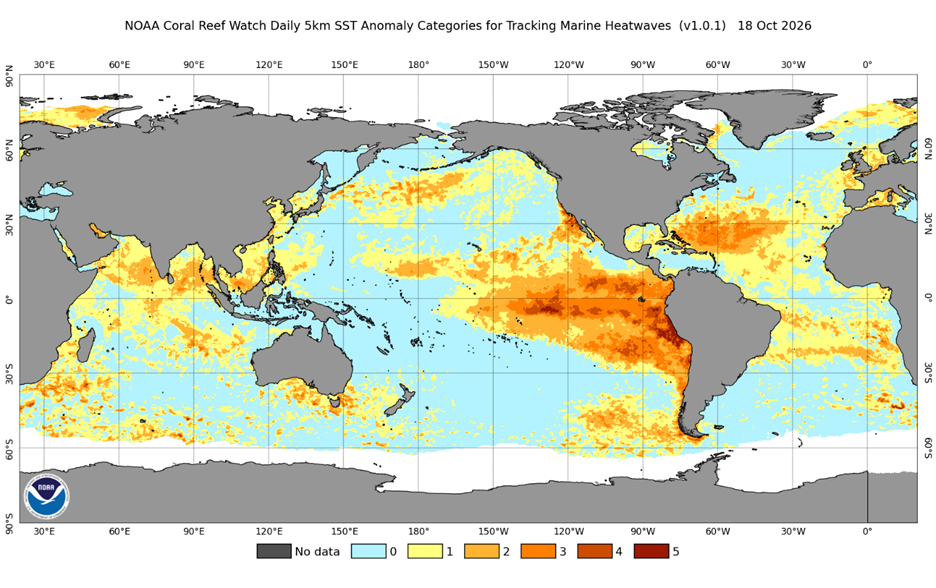
Alright, so we have the background sea level rise from fossil fuel-driven climate change covered. But something else climate change-related is occurring on a much more local scale: a marine heatwave. This particular marine heatwave has been ongoing off the coast of California since earlier this year. According to NOAA’s Marine Heatwave Watch, a category 4 marine heatwave, which is an “extreme” marine heatwave, is currently occurring off the coast of Baja California and the central and southern California coasts.
In the last section, I noted that when water is warmer, it expands. Well, we’re seeing this occur with this localized marine heatwave. So, not only are we seeing sea level rise from the overall global warming of the oceans from climate change, but we’re also seeing sea level rise from this localized marine heatwave. There are estimates of this marine heatwave contributing from 6 to as much as 10 inches of extra water height to a normal tide (on top of the 8 extra inches from climate change).
Kelvin waves on the California coast are from super El Niño
The first two sections covered the effects of global and localized climate change on California coastal water levels, but we also know that we’re at the beginning of a very strong, or “super,” El Niño event. El Niño can raise water levels off the coast of California by about 6-12 inches through something called Kelvin waves.
As you’ve probably read by now, Kelvin waves are not massive storm waves or tsunami waves. In fact, they’re invisible to the human eye, traveling under the surface of the water. The mechanism is this: during an El Niño event, winds blowing from east to west over the equator in the Pacific Ocean weaken, allowing for ocean water that is normally pushed westward toward Indonesia to essentially slosh back across the Pacific from west to east.
Eventually, this vast wave of ocean water sloshes up against South America, splits in two, and the northerly wave runs up the Central American coast under the surface of the water. This is exactly what’s happening off the California coast: a bulge of water is running up the Central American then North American coasts, raising sea levels with it.
A Kelvin wave already made its way up the coast earlier this month, helping to produce higher tidal heights that pushed Tropical Storm Rachel’s waves into homes. But another 3 to 4 will run up the coast before this El Niño event ends later this winter.
Another thing to mention: Kelvin waves bring with them warmer water from the Tropical Pacific Ocean. Each time a Kelvin wave runs up the coast of California, it warms the water, strengthening the marine heatwave, and leading to more thermal expansion (on top of the sea level rise from a greater volume of water sloshing up the coast!). This warming can remain off the coast, even as the Kelvin wave passes, and can be compounded when the next Kelvin wave passes through.
Put it all together…
When you combine the effects of sea level rise (1) from the annual peak in king tides, (2) from multi-year tidal cycles, (3) from climate change, (4) from the climate-driven marine heatwave, and (5) from the approaching Kelvin waves, you get a tidal height that is nearly 4+ feet above normal. These factors on their own can and do cause coastal flooding, especially during a peak Kelvin wave or peak king tides. Together, they make a dangerous combination.
…and add storms on top
But as we saw a preview from Tropical Storm Rachel earlier this month, a tremendous additional threat is the wave action on top of this sea level rise (though 4+ feet on its own is already enough to cause significant coastal flooding).
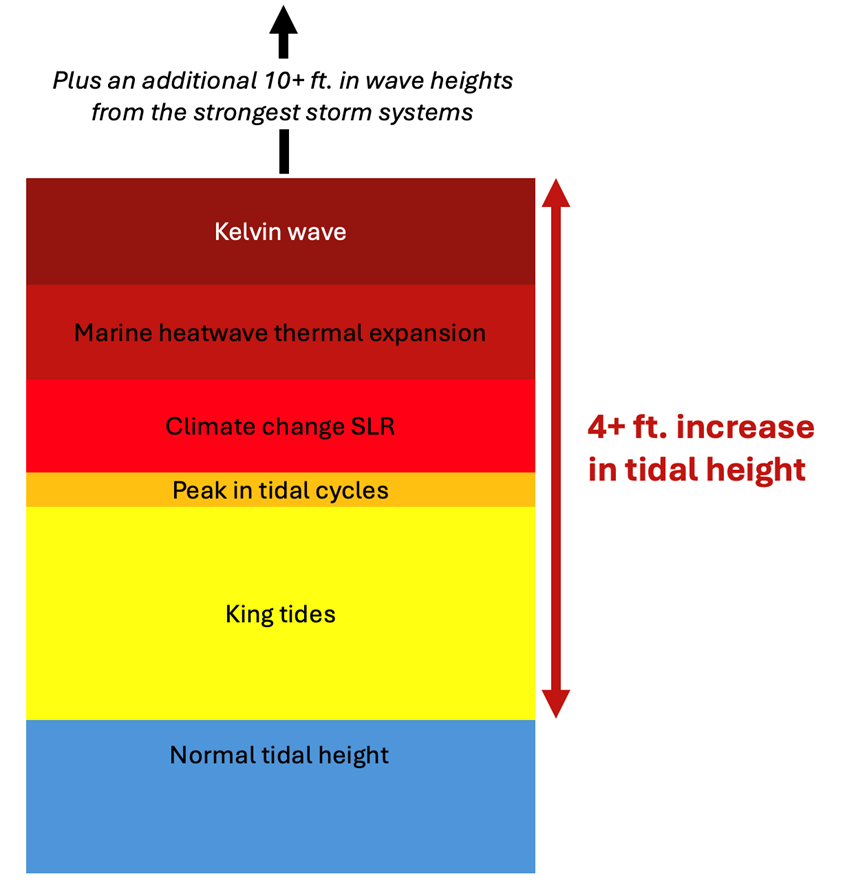
As I mentioned in my last El Niño blog, the jet stream, which is a river of fast-moving air in the upper atmosphere that steers storm systems, often shifts over California during an El Niño, bringing an increase in storm activity and rainfall to the Southwestern US. Storms, like those associated with the Pineapple Express, can bring significant wave heights (over 10+ feet in the strongest storms) to coastal California, mainly due to winds associated with these storms.
These waves, on top of the sea level rise from the aforementioned factors, could lead to record-breaking, historic coastal flooding this winter. In preparation, Governor Newsom declared a State of Emergency last month, partly for the expected damaging coastal erosion.
Climate change is a threat multiplier
What is happening in California reflects the reality that we live in a fundamentally different climate system than the one a century ago. Yes, California has observed El Niños and king tides for thousands of years, but fossil fuel-driven climate change is fueling marine heatwaves, a remarkably active Pacific hurricane season, and significant background sea level rise.
Intense storms producing waves greater than 13 feet in height occurred twice as frequently in the 1996-2016 period than the 1949-1969 period, according to a 2023 study. And since 1900, human-caused sea level rise has quadrupled the frequency of coastal flooding events. Furthermore, there is evidence that El Niños are getting more intense due to fossil fuel-driven climate change, which directly influences the strength of coastal Kelvin waves.
To follow the most recent updates on the El Niño and the threat of coastal flooding and harm this winter, the California Institute for Water Resources and Listos California have put together a dashboard of resources that will be useful for planning as well as monitoring.
Although California is a wealthier state than many other states and has a strong emergency management system, it still needs federal assistance to help communities recover after disasters. El Niño is causing compound and repetitive impacts on California’s coastal communities in addition to the impacts from an active Pacific hurricane season
As we’re witnessing these unprecedented events, it left many of us incredulous that FEMA’s administrator, Cameron Hamilton, would make good on the Trump administration’s intention to put the disaster response and recovery burden onto local and state governments. Governor Newsom immediately criticized this policy, reminding everyone that FEMA has a fundamental responsibility to help people before, during and after disasters. It is going to be a huge challenge for people and communities to weather this likely unprecedented flooding, especially for households of color and those with people living in poverty, who are substantially more likely to be affected.
And of course, we wouldn’t be in this position if it weren’t for the burning of fossil fuels. It is critical we continue to hold the fossil fuel industry accountable for the deliberate spread of disinformation and profiting off the polluting of our planet and dismantling of our stable climate.